GatorAI
GatorEye with GatorAI delivers powerful solutions through innovative drone-based data fusion.
www.gatorAI.org
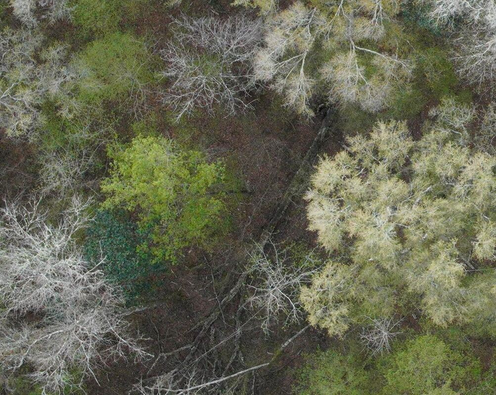
Ultra-res visual image zoom subset collected by GatorEye XTR at the San Felasco Plot
|
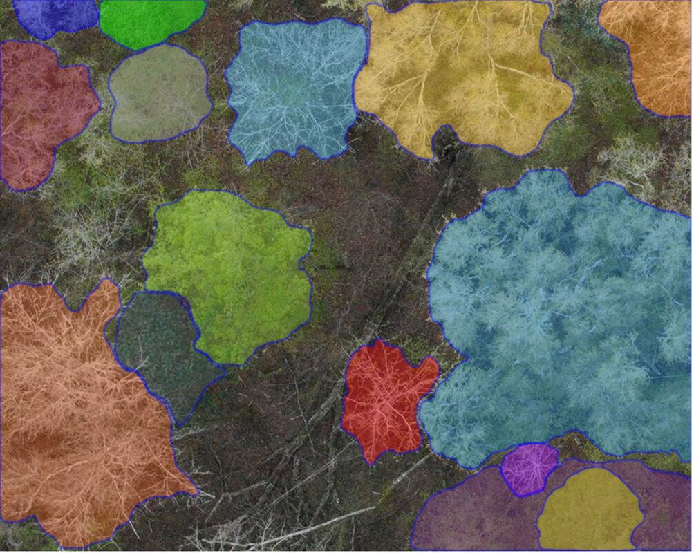
Visual example of image segmentation conducted by the AI 'Segment Anything' algorithm.
|
GatorAI, an integral component of the GatorEye program, is an advanced artificial intelligence-driven platform designed to process ultra-high-resolution imagery captured by the GatorEye XL or XTR visual cameras and similar sensors. The platform begins by converting the imagery into 'quilted microtiles,' AI-optimized image segments that serve as the primary input for GatorAI. This conversion utilizes sophisticated segmentation algorithms, including the Meta segment anything algorithm for both visual and lidar-derived data. GatorAI then systematically analyzes these microtiles to identify structural features, classify tree species with associated uncertainty metrics, and detect critical environmental disturbances such as downed woody debris, burned areas, or other relevant elements, including humans, vehicles, and land cover classes. Employing a multi-model consensus discursive methodology, the platform integrates highly specialized AI models through the deployment of tailored agents and proprietary parameterization techniques to optimize performance and outcomes. Future enhancements under development will incorporate additional data types, such as lidar and hyperspectral products, thereby augmenting the ecological monitoring and research capabilities of the GatorEye program through a sophisticated fusion of advanced image acquisition and artificial intelligence technologies.
Citation: The #GatorAI system is detailed and citable in the GatorEye overview document, as described here.
Inputs:
1) Image (".jpeg, .jpg, .png or .gif" format required): High-resolution visual (e.g., micro-tile) image of crown.
2) Text: "Lat, Long, month" (of image acquisition; DD format) OR in USA: "city, state, month" (of image acquisition)
Raster output (internal workflows):
Mapped labeled quilted microtile grid with associated table (XY location indicated) with data table columns of the "streamlined" output information (as shown above)
Text output: Associated microtile information (as shown in the example output below):
family, genus, species, common name, mortality %, coarse woody debris (%), and species identification probability %
Validation: Images and detailed validation results are available at this link. Initial validation was conducted using drone images sourced from existing literature. No pre-training was performed, and images were selected globally, and ongoing, provided they were drone-acquired images of tree crowns at different zoom levels, with known locations, acquisition months, and species identifications for post-identification accuracy assessment. The GatorAI memory was completely cleared between image identifications, and no additional information beyond what was described in the ‘Inputs’ section was supplied to the system. Validation A utilized high-zoom level drone images, the image acquisition is detailed here. The percentage of correct identifications varied by taxonomic level, with accuracies of 72% for Family, 69% for Genus, and 42% for Species.
Versions
v1.0 - 11/2023 - beta release
v1.1 to 1.36 - continued improvements in interface and identification capabilities
v1.37 - 06/2024 - streamlined output and quality improvements
*** Online beta access is now available on a case-by-case basis for single image processing (e.g., beta testing). If interested, please contact PI Broadbent at [email protected]
Below: Example full descriptive complete output for a crown (below) from the above segmented image in full output text format versus streamlined format (above) for mapping raster products.

Appendix A. Example full output for one microtile (as shown above)
GatorAI v1.37: Please upload microtile and acquisition: latitude, longitude, month.
Input: Image + "Melrose, Florida, May"
Detailed parameter results:
1. **Visibility Clarity Score**: 9
2. **Leaf Shape**: 8
3. **Leaf Arrangement**: Alternate
4. **Leaf Margin/Edges**: Smooth, slightly wavy
5. **Leaf Texture**: Leathery
6. **Leaf Venation**: Pinnate
7. **Leaf Size**: Length: 4-6 cm, Width: 2-3 cm, Area: ~10 cm²
8. **Leaf Color**: Dark green
9. **Leaf Thickness**: Medium
10. **Leaf Tip**: 4
11. **Leaf Base**: Rounded
12. **% Green Leaves**: 90%
13. **% Discolored Leaves**: 5%
14. **% Dead Leaves**: 5%
15. **Internode Distance**: 5-10 mm
16. **Leaf Glossiness**: 6
17. **Overall Foliage Density**: 85%
18. **Branching Pattern**: 7
19. **Twig Color**: Light brown
20. **Twig Thickness**: 1-2 mm
21. **Fruit Shape**: Acorn-like
22. **Fruit Size**: Length: 2-3 cm, Width: 1-1.5 cm, Volume: ~2 cm³
23. **Fruit Color**: Brown
24. **Fruit Surface Texture**: Smooth
25. **Fruit Arrangement**: Clustered
26. **Fruit Density**: Low
27. **Flower Shape**: Small, inconspicuous
28. **Flower Size**: Diameter: ~0.5 cm
29. **Flower Color**: Yellow-green
30. **Flower Arrangement**: Clustered
31. **Petal Count**: 5
32. **Petal Margin/Edges**: Smooth
33. **Flowering Density**: Low
34. **Flowering Period**: 4-6 weeks
35. **% Fruiting Branches**: 20%
36. **% Flowering Branches**: 30%
37. **Fruit Drop Rate**: 20%
38. **Flower Drop Rate**: 25%
39. **Overall Fruit Density**: 10%
40. **Overall Flower Density**: 15%
41. **Fruit Size Variation**: 1-2 cm³
42. **Flower Size Variation**: 0.4-0.6 cm
Potential species ordered by identification confidence:
- Fagaceae, Quercus, Quercus virginiana, Southern Live Oak, 10%, 15%, 85%
- Fagaceae, Quercus, Quercus laurifolia, Laurel Oak, 15%, 20%, 75%
- Fagaceae, Quercus, Quercus geminata, Sand Live Oak, 12%, 18%, 70%
- Fagaceae, Quercus, Quercus nigra, Water Oak, 18%, 22%, 65%
- Fagaceae, Quercus, Quercus michauxii, Swamp Chestnut Oak, 20%, 25%, 60%