GatorEye data usage Terms and Conditions
Use of GatorEye data, workflows, or derivative products (hereafter referred to as 'GatorEye data') is offered for viewing purposes only. All other uses are strictly prohibited except as described herein. Uses other than viewing may be allowed only after initiating a discussion with and receiving written permission of both co-directors Eben Broadbent and Angelica Almeyda Zambrano in their sole discretion. Usage permission will only be granted on a study-by-study basis (e.g., publication, presentation, poster, report), who maintain final approval of the version. Studies using GatorEye data will be conducted in close collaboration with the co-directors, specifically as relates to drafting the work and revising it critically for intellectual content, and who will be offered co-authorship on all resulting products (e.g., publications, presentations, posters, reports). As such, the GatorEye co-directors are able to maintain and be held accountable for all aspects of GatorEye related studies, including the accuracy and integrity of all parts of each study. GatorEye field data collection and processing requires extensive work and collaboration, as such additional required GatorEye collaborators may be assigned by GatorEye co-directors on a study-by-study basis. Redistribution of data is not permitted; instead, interested parties should be directed to www.gatoreye.org. Please contact Eben Broadbent with any questions at [email protected]. If you would like to propose a collaboration, please provide a paragraph summary of what is intended for consideration by the co-directors via email, and we will respond as soon as possible.
To access data please simply agree to the terms and conditions above by typing (or copy / paste) as the password the following text between the quotation symbols "I agree to the GatorEye data usage Terms and Conditions" to access the data download site at the below campaign links. This publically accessible data portal represents the exclusively authorized location for data distribution. As of May, 2024, more than 900,000 files totaling more than 17 TB of GatorEye data are available, making this one of the very largest non-institutional/commercial data download portals in the world. It is explicitly forbidden to distribute this data as public domain content. The terms and conditions presented in this document adhere to a globally recognized standard for publicly shared datasets, as illustrated by the following examples.
** All data is provided by default in the closest UTM zone (N/S), WGS-84, and with a vertical datum of either (pre-2020) ITRF 2014 or (post-2020) WGS-84 elliptical, all in meters. Vertical and horizontal epoch dates change with base station date, and are the date of acquisition.
*** A detailed description of deliverables is provided in the GatorEye overview manuscript at: GatorEye
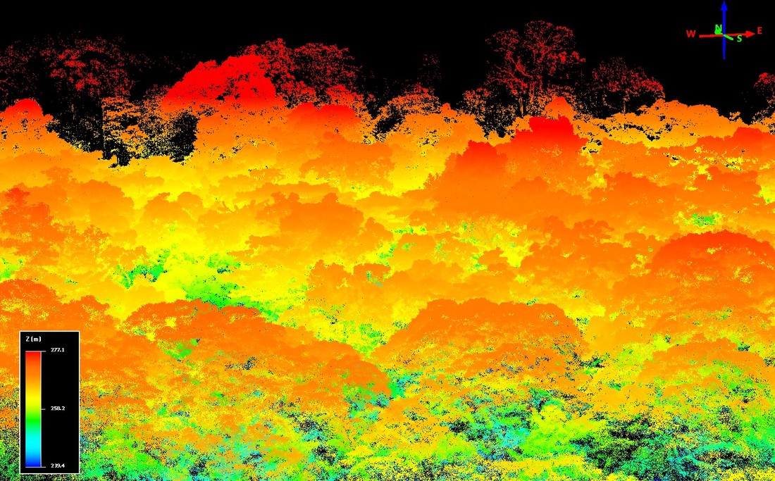
**** Mission processed product visuals are provided in this dynamic updated document
2016 Costa Rica Osa Verde
2017 Brazil Amazon July, team
2017 Brazil Cerrado July, team
2017 Costa Rica La Selva, team
2017 New Hampshire Dartmouth 2nd Tract
2017 Georgia Jones Center NEON tower 091917, team
2017 Florida OSBS NEON Tower North Airshed 092518
2017 Florida Seahorse Key 102417
2018 Florida OSBS Lake McCloud 020618
2018 Florida Longleaf Pine Reserve 031618, team
2018 Florida Longleaf Pine Reserve 061218, team
2018 Florida Pellicer Creek
2018 Florida Natural Areas Teaching Lab (NATL) 022718
2018 Florida OSBS Lake Barco Transects 032718
2018 Florida Kanapaha Calibration 042318
2018 Florida Austin Cary Forest Tower 050318
2018 Florida Pellicer Creek 050418
2018 Florida Seahorse Key 051218
2018 Florida Shell Mound 051818
2018 New Hampshire Dartmouth 2nd Tract May
2018 Mexico Chiapas June, team
2018 Florida Fort Matanzas 060118
2018 Florida UF Ag Station 061818
2018 Peru Andes - Amazon Plots July, team
2018 Peru La Molina Jardin Botanico 071118, team
2018 Peru Tumbes July, team
2018 Costa Rica La Selva July , team
2018 Brazil USP Piracicaba LASTROP 062218, team
2018 Brazil Anhembi June, team
2018 Florida VARIETIES 092818
2018 Florida OSBS NEON North Airshed 101218
2018 Florida Austin Cary Forest Tower 110118
2018 Florida Apalachicola 111518
2018 Florida IMPAC II 112118
2018 Florida Cedar Key 121118
2018 Florida Cone Park 121218
2019 Panama STRI Barro Colorado Island (BCI) 020219
2019 Florida Cone Park 030819
2019 Florida Austin Cary Forest Tower 053119
2019 Florida OSBS ForestGeo 060319
2019 Mexico June * res
2019 Peru Los Amigos June
2019 Brazil July, team * res
2019 Florida OSBS Big Plot 082319
2019 Brazil Sao Paulo State Aug
2019 Brazil Curitiba Sept, team
2019 Panama BCI October
2019 Brazil Iguassu Falls 100919
2019 Florida Jennings State Forest 102519
2019 Florida Apalachicola 110819
2020 Costa Rica Tropidry Feb 2020
2020 Costa Rica SRNP Feb 2020
2020 Florida OSBS Big-Plot and ForestGeo 092320
2020 New Hampshire ASCC Oct
2020 Florida Gainesville Urban Oct Nov
2020 Florida Gainesville Urban Oct Nov Visual
2020 VA SCBI ForestGeo 111720
2020 MD SERC ForestGeo 111820
2020 California Site A 120920
2020 California Site B 121020
2020 Florida Lake Tallavana 122120 visual
2020 Florida Lake Tallavana 122120
2021 Alabama Moundville 021921
2021 Florida Archbold 022521
2021 Florida VARIETIES 030821
2021 Costa Rica Ridge to Reef 031321 to 031821
2021 Florida Austin Cary Forest 050421
2021 Florida UF Cultural Plaza 050721
2021 Florida Seahorse Key 051021
2021 Florida Urban Kanapaha 090921 - 'GatorEye Lite'
2021 Florida ACF 092821 - 'GatorEye Lite'
2021 Florida ACF 101421 - 'GatorEye Lite'
2021 Caribbean Oct - 'GatorEye Lite'
2021 Florida IMPAC 030521
2021 France Oct - 'GatorEye Lite'
2022 Ecuador Jan - 'GatorEye Lite'
2022 Florida Cedar Key Richard's Island 012322 - 'GatorEye Lite'
2022 Florida Citra 012822 - 'GatorEye Lite'
2022 Florida CWD Panhandle Sites 022422 - 'GatorEye Lite'
2022 Florida UFL Flavett Field 022822 - 'GatorEye Lite'
2022 Hawaii Palamanui 030922
2022 Hawaii Palamanui 031022
2022 Hawaii Laupahoehoe 030722
2022 Hawaii Laupahoehoe 031122
2022 Hawaii Palamanui 070622
2022 Hawaii Palamanui 070722
2022 Hawaii Laupahoehoe 070822
2022 Hawaii Laupahoehoe 101222
2022 Hawaii Palamanui 101322
2022 Florida SeaHorse Key 050922 - 'GatorEye Lite'
2022 Florida Blues Creek Ravine 051122 - 'GatorEye Lite'
2022 Florida OSBS ForestGeo 060822 - 'GatorEye Lite'
2022 Florida OSBS ForestGeo 090122 - 'GatorEye Lite'
2022 Philippines June
2022 Costa Rica Las Cruces July
2022 Brazil NewFor 082822 - 'GatorEye Lite'
2022 MD SERC ForestGeo 071222
2022 MD SERC Wetlands 071222
2022 MA Harvard Forest ForestGeo 071422
2022 Florida FWS Forest Plots Oct 2022
2022 WA Wind River GL 090722
2022 VA SCBI ForestGeo 071122
2023 Florida Cedar Key Jan
2023 Florida Gully 042823
2023 Florida IMPAC-II 051023
2023 Florida UF baseball stadium 051023
2023 Florida ACF XTR 051623
2023 MD SERC ForestGeo 081323
2023 VA SCBI ForestGeo 081323
2023 MA Harvard Forest ForestGeo 081423
2023 WA Wind River GL 092623
2023 Florida OSBS ForestGeo GL 100123
2023 Florida Rookery Bay & 10000 Islands NWRs 110223
2023 Puerto Rico 111423
2023 Puerto Rico 111623
2023 Puerto Rico 111723
2024 Florida San Felasco Hammock 'Big Plot' 030424
2024 Florida OSBS Crowns 050824
2024 Florida VARIETIES 050824
2024 Florida IMPAC-II 050924 *ANAFI USA
2024 Florida ACF XTR 050924
2024 Florida SeaHorse Key 051324
2024 Florida OSBS ANAFI Crowns 070324
2023-2021 PRISM * res
Calibration / Validation / Reference datasets
2018 Florida ACF 05-03-18 and 11-01-18, precision cross-georeferenced (XYZ) and coupled with field cm GNSS points of ground points and understory height in longleaf pine ecosystems - suitable for development of DEM and understory DSM algorithms.
Final products
Lidar data is typically distributed in a folder named 'final products', following processing through the GatorEye lidar multi-scalar post-process workflow prior to distribution (see document for details and citation). The final products specifically are:
A) Digital elevation model (DEM) in raster and LAS grid point cloud format.
B) Digital surface model (DSM) in raster and LAS grid point cloud formats.
C) Canopy height model (CHM) in raster and LAS grid point cloud formats.
D) LAS point clouds in ellipsoidal height, and height normalized (e.g., CHM) against the digital elevation model.
Version updates
07/29/22 - Note that 'teams' pages are only created per request or special circumstances as have proven difficult to keep updated with affiliations and contact information. Rather, this is provided during discussions related to specific collaborations.
09/09/21 - 'GatorEye Lite' data is now being uploaded and provided here as well as 'GatorEye' data. This new system is comprised of a M300 RTK with Zenmuse L1 and Micasense Altum with DLS.
02/15/20 - v218 - completed of the GatorEye LiDAR Multi-Scalar Post-process (GLMSPP). Produces a DEM, DSM, CHM, Pit-free CHM, and flightline merged Ellipsoidal and Height Normalized point clouds, with point classification of ground, non-ground, building, tree, shrub point classes.
01/15/20 - Gen 3 build complete!
12/22/19 - Gen 3 build in progress which now includes up-welling (Nano) and down-welling hyperspectral sensor (Flame) integration (for line-by-line reflectance calculation), radiometric thermal integration with custom external shutter, upgraded 32 beam long-range Lidar, and high-res visual sensor with 72 degrees FOV upgrades.
12/22/19 - v208, ongoing improvements in code in MSGPD workflow, incorporating code parameter groups, specialized for long-leaf pine forests, and for archaeological applications (field surveys, and dense topography).
12/06/19 - v200 multi-scalar ground point detection (MSGPD) and product workflow released. Now based in R, and incorporating improved interpolation algorithms from LidR for DEM generation.
11/01/19 - v80 multi-scalar ground point detection and product workflow released.
06/15/19 - LiDAR sensor upgraded to 250m range 32 laser sensor (Ultra Puck 32c).
01/25/19 - Hyperspectral sensor factory radiometrically calibrated.
10/09/18 - LiDAR post-processing updated to version 33. Core products now include:
- Digital Elevation Model (DEM), 0.5 m resolution, raster .tif format
- Digital Elevation Model (DEM), 0.5 m resolution, point cloud, .laz format
- Digital Surface Model (DSM), 0.5 m resolution, raster .tif format
- Canopy Height Model (CHM), 0.5 m resolution, pit-free algorithm, raster .tif format
- Full point clouds, filtered, elevation 'final elevation merged', .laz format
- Full point cloud, filtered, height above DEM, 'final heightz merged', .laz format
- DSM point cloud, 0.5 m resolution, interpolated non-reflective ground spaces (e.g., asphalt, water), .laz format, 'canopy_thin_ground_filled_merged_thin'
10/10/18 - LiDAR firmware upgrade reduces sun related noise.
09/15/18 - Post-processing LiDAR workflow products will be shared for all missions, starting to work through them now. Hyperspectral data shared for selected missions as it is processed. Note: Mosaic (3 to 1 band spectral binned) hyperspectral data is available for 2018 Florida OSBS Lake McCloud as today.
02/02/18 - Future LAS data will be provided as LAS version 1.2 for greater compatibility with open source software. In the LiDAR folder we will have an additional folder named the version of the LAS file if multiple LAS versions are provided.
01/31/18 - Lever Arm (IMU to GNSS Antenna) values corrected. All LiDAR versions after this date have correct lever arm values included (via IE processing) and are at full density (per 12/01/17 update below). We will now also provide flight line point cloud (.las) for each mission, as well as merged flight lines unique to each plot (if it is a plot based mission). We are also providing .tif versions of all RGB images with an associated Pix4D format file having SBET IE differential corrected location and view angle values (accurate to within < 2 cm XYZ).
12/01/17 - New LiDAR processing workflow increases point cloud density by 2400%. LiDAR data folders after this date (standard folder format will be "LiDAR_vMMDDYY" are at full point cloud density.
Additional Program-related Datasets
CDK = Community Drone Kits
2022 Florida UFL Ethnoecology gardens 051122 - 'CDK Mini SE v1'