SPATIAL ECOLOGY & CONSERVATION (SPEC) LAB
  • Home
  • People
    • Join us
  • Research/Data/Flow
    • Data download
    • Geospatial Plot data workflow (GeoPlot)
    • Global Aboveground biomass Potential (GAP)
    • Global Ecosystem Structure Index (GESI)
    • PARAGUAYAN PERMANENT PLOT NETWORK (PPMB)
    • 2ndFOR
    • Sustainable Tourism >
      • Lapa Rios
    • Monitoring
    • Biodiversity Frameworks
    • References
    • SPEC Lab Internal
  • GatorEye
    • GatorEye Data Access >
      • Intellectual Property
      • Altum processing tips
      • ForestGeo
    • XL
    • XTR
    • CDK
    • ORC
    • ORCA
    • Postprocessing analytics
    • Hyperspec: links & refs
    • LiDAR: links & refs
  • GatorAI
    • GatorAI web app
  • BigPlotNetwork
  • San Felasco Big Plot
  • StormCloud
  • Teaching
    • UAS Practicum
  • Info for students
    • Schedule
    • Templates
    • Writing resources
    • AI in science writing
    • Example student products
    • Funding >
      • NASA FINESST Fellowship
  • Photos
    • Puppies
  • Directions
  • Links
  • Osa, Costa Rica
  • SoundMapper4D
  • Sentinel Oaks
  • Donate


​
​GatorEye XL


The GatorEye XL is a key component of a new long-term multi-institutional academic-industry-government partnership, specifically Phoenix Aerial and Harris Aerial, and is directed and managed by Dr. Almeyda Zambrano, who also leads mission logistics, data pre-processing, and quality control. Dr. Broadbent supports the vision in new hardware and workflow development for efficient large-area multi-sensor data collection. GatorEye XL is a collaboration with Phoenix Aerial and Harris Aerial, and with a data collection focus in North America, and with large-area (1000s km2) data collection having started in 2021 and ongoing.
Picture
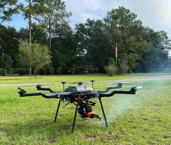
Figure 1. GatorEye XL flight platform, a hybrid battery-gas powered system with flight times exceeding 2 hours with a 6 kg GatorEye payload. System: Harris Aerial

CONTACT

Center for Latin American Studies
School of Forest, Fisheries and Geomatics Sciences
University of Florida
[email protected]  / [email protected]
Picture

  • Home
  • People
    • Join us
  • Research/Data/Flow
    • Data download
    • Geospatial Plot data workflow (GeoPlot)
    • Global Aboveground biomass Potential (GAP)
    • Global Ecosystem Structure Index (GESI)
    • PARAGUAYAN PERMANENT PLOT NETWORK (PPMB)
    • 2ndFOR
    • Sustainable Tourism >
      • Lapa Rios
    • Monitoring
    • Biodiversity Frameworks
    • References
    • SPEC Lab Internal
  • GatorEye
    • GatorEye Data Access >
      • Intellectual Property
      • Altum processing tips
      • ForestGeo
    • XL
    • XTR
    • CDK
    • ORC
    • ORCA
    • Postprocessing analytics
    • Hyperspec: links & refs
    • LiDAR: links & refs
  • GatorAI
    • GatorAI web app
  • BigPlotNetwork
  • San Felasco Big Plot
  • StormCloud
  • Teaching
    • UAS Practicum
  • Info for students
    • Schedule
    • Templates
    • Writing resources
    • AI in science writing
    • Example student products
    • Funding >
      • NASA FINESST Fellowship
  • Photos
    • Puppies
  • Directions
  • Links
  • Osa, Costa Rica
  • SoundMapper4D
  • Sentinel Oaks
  • Donate